WebGIS
|
Classes Altitudes above mean sea level (m) |
About the data
The images refer to RGB and supervised classification maps for Vila Chã rocky shore (41.29554° N, 8.73701° W) in Northern Portugal from four sampling campaigns during 2020. The area has a diversified cover with sandy patches and rocky outcrops, colonized with diverse seaweeds, mussels (Mytilus spp.), barnacles (Chthamalus spp.) and limpets (Patella spp.) following zonation patterns described for temperate reefs.
Multispectral data were acquired with a UAV equipped with a MicaSense RedEdge camera. Each supervised classification map was obtained with the QGIS Supervised Classification Plugin (SCP) using 7 training areas for each of the four following classes: Mixed Algae; Mussels and Rock; Rock, Barnacles and Limpets; and Sand. For validation procedures, 3 training areas were used per class, that originated the metrics reported in the table below.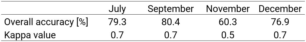
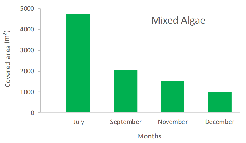
By exploring the layers of different campaigns, a decrease in seaweed cover is
observed from July to December 2020, in line with the predicted seasonal patterns
(see figure below). Fluctuations on the cover of the other classes is the
reflection of sediment movements caused by hydrodynamics, affecting particularly
sand, and recruitment patterns for the main sessile invertebrates.